Key words :
climate change,
climate change
,global warming
,ice sheets
,deep water lakes
,lake ellsworth
,subglacial lakes
,vostok station
,west antarctica
,environment
The Exploration of Subglacial Lake Ellsworth in West Antarctica
23 Jan, 2008 09:43 am
Ever since the discovery, ten years ago, of Lake Vostok as a large deep freshwater body beneath the Antarctic ice sheet, scientists have been fascinated by the potential of subglacial lakes as habitats for unusual microbial life and recorders of unique climate records. While several plans exist to penetrate into and explore these environments, none are more advanced that a UK-led project to investigate Lake Ellsworth in West Antarctica.
Subglacial lakes can be identified using ice-penetrating radar. VHF radio-waves propagate well in cold ice and reflect of boundaries where there is a change in electrical properties. While the most significant boundary occurs at the ice-sheet base, the nature of a radar reflection from a subglacial lake (e.g. a flat, bright echo of constant strength due to the uniform reflections off a mirror-like interface) is distinct from an ice-rock contact (e.g. an undulating, weak echo of variable strength due to scattering at a rough interface; Figure 2).
Deep-water subglacial lakes have inspired biologists to plan their exploration, as unique extreme environments in which unusual micro-organisms might adapt and survive. While this aspect of subglacial lakes research has been given considerable scientific and media attention, we should not underestimate the importance of the two-fold geoscientific rationale behind the future exploration of subglacial lakes.
First, subglacial lakes are highly likely to contain sediments across their floors, which will have accumulated for as long as the lakes have been in existence. For deep-water lakes, this could be as old as the present-day ice sheet, which is of unknown age. In fact the glacial history of the Antarctic ice sheet throughout the Cenozoic is not known well. Sediment records from the floors of subglacial lakes may be able to provide important information concerning past ice sheet changes.
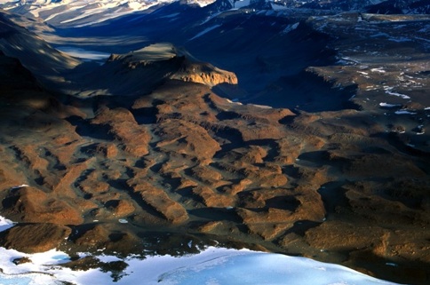
Second, subglacial lakes are evidence of widespread water beneath the ice sheet, which is likely to have an important, albeit poorly known, influence on ice sheet flow dynamics. Recent satellite remote sensing investigations have revealed that subglacial lakes can periodically discharge large volumes of water across several hundred kilometres (Figure 3). In one case, a flux of water of the order of the flow of the River Thames in London was calculated between lakes in central East Antarctica separated by 300 km[4]. The discharge was of the order of 1.8 km3 and lasted for 16 months during 1996-7. As several subglacial lakes are known to exist at the heads of ice streams[2] (the fast flowing rivers of ice that drain the bulk of the ice sheet), changes to the basal conditions of these systems caused by subglacial lake drainage could have serious implications for ice sheet stability and, possibly, global sea-level change. Evidence certainly exists in the morphological record of the ice sheet margin for huge outburst events that left water channels cut >100 m deep into hard rock.
 It is therefore likely that substantial volumes of subglacial lake water have
previously reached the ocean, and could do so again under the glacial processes
identified in East Antarctica.
It is therefore likely that substantial volumes of subglacial lake water have
previously reached the ocean, and could do so again under the glacial processes
identified in East Antarctica.While there are clearly good and exiting reasons to explore subglacial lakes, to do so is challenging from technical, logistical and environmental points of view. As subglacial lakes are pristine environments, and as the levels of life and nutrients are likely to be low, direct examination of these systems must be undertaken in ultra-clean conditions. In other words, contamination of the lake by the access technique must be avoided, and equipment used to measure the lake must be sterile. Hot water drilling offers the best opportunity for efficient clean lake access, as opposed to ice coring that uses an antifreeze drilling fluid or thermo-probing which is notoriously unreliable over even short (<100 m) vertical distances. Once lake access is achieved, instruments can be lowered down the borehole and into the water column (Figure 4), to measure the broad physical, chemical and biological properties of the lake water and sediments.
A UK-led team, involving over 30 scientists from 15 universities and research institutes, and indeed scientists from four other nations, have identified Lake Ellsworth as a prime candidate for exploration[5].
Subglacial lakes research is in its infancy. While plans to explore Lake Ellsworth are being developed (see www.geos.ed.ac.uk/ellsworth), the earliest lake access might take place is in 2012/13 – 100 years since the ‘golden age’ of Antarctic exploration and, of course, the centenary of the Scott expedition to South Pole!
References
[1] Kapitsa, A., Ridley, J.K., Robin, G. de Q., Siegert, M.J. & Zotikov, I. Large deep freshwater lake beneath the ice of central East Antarctica. Nature, 381, 684-686. (1996).
[2] Siegert, M.J., Carter, S., Tabacco, I., Popov, S. and Blankenship, D. A revised inventory of Antarctic subglacial lakes. Antarctic Science, 17 (3), 453-460. (2005).
[3] Siegert M.J., Hindmarsh, R., Corr H., Smith, A., Woodward, J., King, E., Payne, A.J., Joughin, I. Subglacial Lake Ellsworth: a candidate for in situ exploration in West Antarctica. Geophysical Research Letters, 31 (23), L23403, 10.1029/2004GL021477. (2004).
[4] Wingham, D.J., Siegert, M.J., Shepherd, A.P. and Muir, A.S. Rapid discharge connects Antarctic subglacial lakes. Nature, 440, 1033-1036 (2006).
[5] Siegert, M.J. and the Lake Ellsworth Consortium. The exploration of Ellsworth Subglacial Lake: a concept paper on the development, organisation and execution of an experiment to explore, measure and sample the environment of a West Antarctic subglacial lake. Reviews in Environmental Science and Bio/Technology. doi: 10.1007/s11157-006-9109-9 (2006).
Figures and Captions
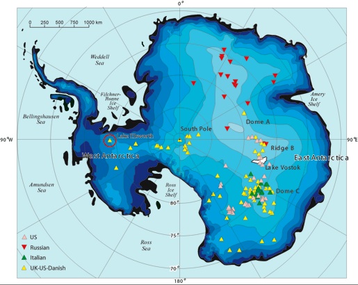
Figure 1. The locations of Antarctic subglacial lakes. Different colours refer to the nation whose geophysical survey was responsible for lake identification. Lake Ellsworth is circled in red.
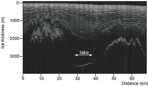
Figure 2. Radio-echo sounding transect across the foothills of the Ellsworth Mountains in West Antarctica, revealing the surface of Lake Ellsworth within a 1-2 km deep trough (probably a former fjord). Note the smooth bright return from the ice water interface as opposed to the undulating signal from the surrounding bedrock. Note also the sloping lake surface, which is a recognised characteristic of a subglacial lake in hydrostatic equilibrium with the overlying ice.
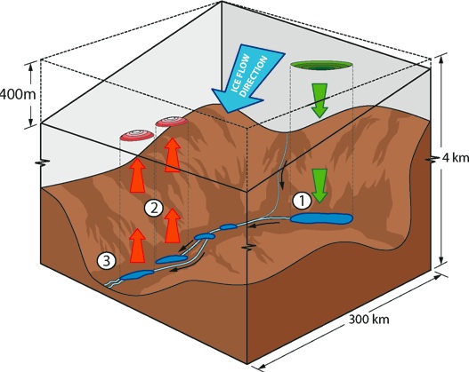
Figure 3. Sudden flow of subglacial lake water beneath the central East Antarctic ice sheet. Satellite altimetry detects (1) ice-sheet surface elevation lowering of around 3 m, signalling the loss of water from a lake 3.5 km beneath and (2) surface uplift of 1-2 m some 250 km away caused by a rapid influx of water. The lakes are located within the a distinct subglacial trench in which, calculations reveal, the flow of water would from one lake to another. The lowering and uplift occur at roughly the same time (within 35 days, which is the repeat cycle of the satellite), which means the flow of water would be of the order of 50 m3 s-1 – similar to the flow of the River Thames in London. Subsequent to uplift, satellite show lowering due to further loss of water downstream (3).
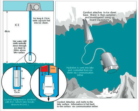
Figure 4. The exploration of subglacial lake Ellsworth. Hot-water drilling is used to access the lake. The hole is likely to be kept open for 24-36 hours, during which time a sterile probe will be released into the lake. The probe will measure the lake’s chemistry and biology, as well as physical parameters such as temperature, density and conductivity. Once the probe has been retracted, a gravity core will be deployed to extract a sample of sediment from the lake floor.


www.geos.ed.ac.uk/ellsworth
including the field blog written by Neil Ross,
Martin Siegert, 24th January 2008